Hi, I'm Chethan — a Cloud Architect writing about software, personal finance, telecom, and automobiles.
-
-
I’m switching off the lights for Earth Hour 2011. Show your support too at http://www.earthhour.org.
-
Yesterday was a great day for Spatial Interoperability analysts. The day was marked with launch of FME 2011 with great feature additions over earlier versions. Support to process LiDAR data has been an important addition. Other notable additions include ability to read and write data into cloud, support for ArcGIS 10, AutoDesk FDO 2011 formats, addition of scheduling tool to the server version and more powerful XML support. Keeping up with Safe’s tradition of valuing user feedback/suggestions, many additions are a result of user requests.
-
Yesterday a revolutionary app was launched in India, the TukTuk Meter, India’s first GPS based auto fare app. Whoever has traveled in India in autos know how driver’s charge the commuters. To counter this local administrations have made auto fare meters mandatory in several towns and cities. Still there have been reports of meter tampering and overcharging. Now a new app developed by MindHelix Technologies is bound to change the situation by allowing you to compare the charges.
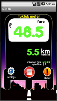
The TukTuk Meter app available for free can run on different platforms -
- Android2.1 (Eclair), Android 2.2 ( Froyo ) or above
- BlackBerry (OS v4.5,v4.6,v4.7, v5.0)
- Symbian S60v3 or S60v5 phones with GPS
- Other smart phones which has GPS and Java.
It is designed for easy operation with a simple start - stop button. Auto fares for different cities can be easily updated. The app makes use of GPS facility provided on phones to trace the path and provide real time distance information. Hence it does not require GPRS/EDGE to function. So download the app right away, try it the next time when you catch an auto and be in a better position to argue with the auto driver!
-
Owning a house is an important objective of one’s life. Everyone wants their house to stand apart in terms of architectural beauty, interiors, furniture etc. This prompts one to go into research mode and look out for all possible options in realizing the dream home. Seeking professional guidance from leading architects has been the way of many. Now leading CAD software maker, Autodesk has come up with a unique online solution - Autodesk Homestyler.